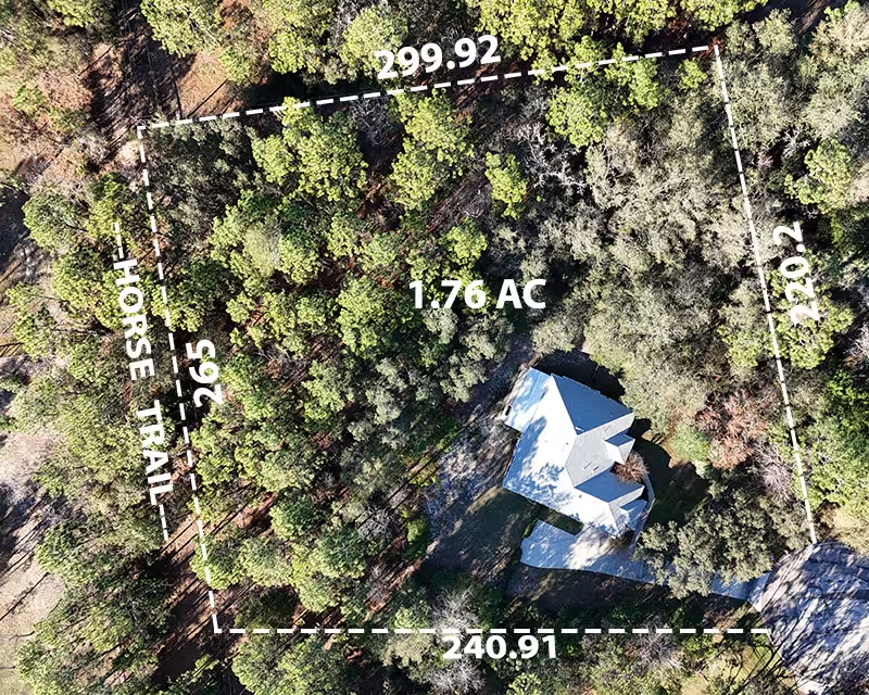
Drastically Improve Real Estate Listings on Zillow and MLS
Highlight Property Boundaries, Landscape Features & Acreage
Real Estate and Property Marketing
Showcasing Properties: Whether it’s a sprawling estate, a commercial development, or a residential neighborhood, high-resolution aerial imagery provides a unique view of the property. Potential buyers can see the layout, landscaping, and surrounding features from above, which can significantly enhance their understanding of the space and result in faster sales for higher amounts.
Highlighting Features: Aerial photography and video allow real estate professionals to emphasize key features such as waterfront access, proximity to parks, or scenic views. These visuals create an emotional connection with potential buyers and help properties stand out in a competitive market.
Contextualizing Location: Aerial shots also provide context by showing nearby amenities, transportation links, and neighborhood characteristics. Buyers can assess factors like accessibility, privacy, and overall appeal.
Environmental Monitoring and Surveying
Land Use Planning: High-resolution aerial imagery aids urban planners, environmental agencies, and land developers. It helps them assess land use patterns, identify suitable locations for infrastructure projects, and plan for sustainable growth.
Ecological Studies: Researchers use aerial photography to monitor ecosystems, track changes in vegetation cover, aquatic growth in bodies of water to gauge the effects of fertilizer runoff, and study wildlife habitats. From assessing deforestation to monitoring wetlands, these images provide critical data for conservation efforts.
Infrastructure Inspection: Aerial video can be invaluable for inspecting large structures like bridges, power lines, and pipelines. Drones equipped with high-resolution cameras can capture detailed footage, allowing engineers to identify maintenance needs or potential issues without risking human safety.
In summary, high-resolution aerial photography and video serve not only as visually stunning art but also as powerful tools for communication, analysis, and decision-making across various domains. Whether you’re selling a property, conducting research, or ensuring infrastructure integrity, these images offer a fresh perspective that can make a significant impact!
